
User login
Language
Anonymous's groups in this site
User is not a member of any group.
Your groups across all your sites
User is not a member of any group.
Recent Content
Who's online
There are currently 0 users online.
You are here
CLICK HERE - FAR ROCKAWAY RESILIENCE CENTER
CLICK HERE - ROCKVILLE RESILIENCE CENTER
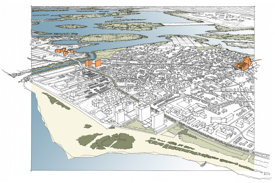
Far Rockaway Resilience Center
The Resilience Center of mixed commercial uses, housing, and job training will shelter Rockaways residents in times of need. Satellites will retrofit existing multi-family housing units for inhabitants to shelter in place safely, with floodproof levels, raised community centers, and uninterruptible services.
The Rockaways have been an attractive destination for vacationers since the Cross Bay Bridge and the development of the beach and boardwalk in 1930. Construction of the elevated train and the first low- and moderate-income projects arrived in 1955. Restoring downtown as a desirable environment for housing and essential services is especially critical when the historic commercial areas are on high ground.
The proposed Resilience Center will be located at the terminal stop of the A train, along the ridge, at elevation +35’. The center will include an urban grocery and retail shops, commercial uses, a job training center (that doubles as a public safety shelter for residents from nearby low-lying neighborhoods), and a mix of housing types. It will serve as an important link between the A train to the LIRR station one-quarter mile away, for increased mobility options.
A future cut through the peninsula to restore water circulation to the east side of Jamaica Bay is under study by the Army Corps of Engineers. By the time it is complete, many of the public housing facilities will be at greater risk for flooding and isolation. Satellite projects will retrofit multi-family housing (such as at Beach Channel Drive and Beach 40th Street) so that residents may shelter in place, by removing dwelling units at the grade level and relocating these units on-site, moving sensitive equipment out of the floodplain, providing self-sufficiency features, and providing a resilient community center for resident activities as well as emergency functions.
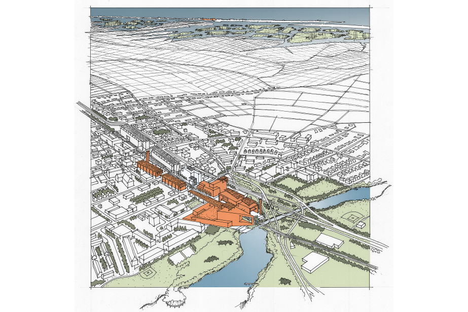
Rockville Resilience Center
Rockville Centre is the closest high ground to the barrier island, and situated along the Long Island Rail Road, the Resilience Center is planned as a transit-oriented development.
Long Island is densely settled by over 2.5 million people and about 41,000 people on Long Beach Barrier Island. Sea level rise and increasing storm surge will require intensification of the high ground in both locations, along with development of strong connections for commuting, trade, and evacuation. On the barrier island, a satellite relocating the transit center will be built at flood-resistant elevation near the east-west corridor of Broadway, including a community activity hall, commercial functions, and senior housing. In times of crisis, if evacuation from the island is not possible, the hall becomes a community shelter, and seniors may remain at home.
By 2080, much of the barrier island will be underwater. Cars will be left at Island Park, and access will be via water taxi or an elevated rail line. Marshes will reclaim the lower bayside of the island, hosting only independent colonies of stilt houses. An elevated east-west streetcar along Broadway will connect the remaining communities of the 9-mile long island. Ground floor uses will transition to floodproof retail and commercial spaces.
At the inland location, Rockville Centre demonstrates safe elevation, net-zero utility use, mixed commercial uses, restored estuary edges and recreation, and intensified housing along the Long Island Rail Road line. It models the self-sufficiency and increased density of a new type of transit-oriented development.


Recent Comments